
KlauPPK from Klau Geomatics is a suite of software and hardware solutions to bring accuracy to aerial mapping from drones and manned aircraft.
SOFTWARE
Save time and money
while increasing accuracy and efficiency
Get the best possible PPK results from your DJI drones
Mavic3 Enterprise, M300, M30, M210RTK and P4RTK
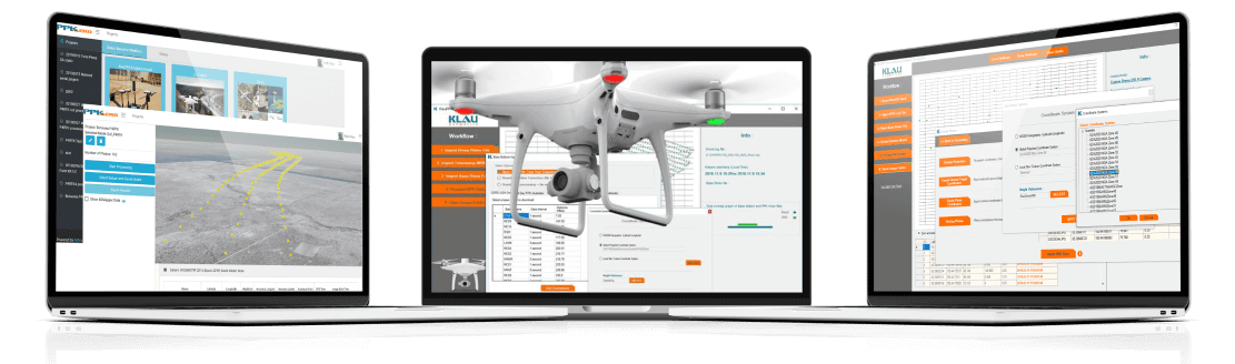
KlauPPK for DJI RTK drones
The same processing technology as our KlauPPK software (industry leading since 2015), adapted for data from DJI drones.
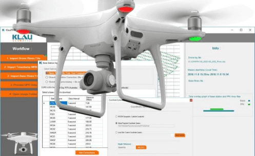
KlauPPK hardware is not required, just import the flight data from your drone, with base station data, to create the best possible camera positions using DJI hardware.
US$ 1250
AUD$1850
Download a free trial, right now. Full functionality for a week, to process as many jobs as you like. If you like it, contact us to buy an activation key.
KlauPPK Software customized for DJI RTK data. Process the data from your DJI in Post Processed Kinematic mode, for more reliable and acccurate results than RTK.
Better Results. No data loss or initialization loss from RTK radio link limitations. All collected data is processed with similar algorithms to RTK, run forwards and backwards through the data.
Improved Operations. PPK offers greater flexibility in operations, longer range from the base, is more reliable, more accurate and easier to use.
Proven Functionality. The same features as the KlauPPK software, proven with years of use by hundreds of customers around the world.
Integrated CORS base stations and MakeItAccurate. Find your nearest base station data automatically, with direct integration into NGS NOAA (USA, free), AllDayRTK (Aus/NZ) and Smartnet (global) CORS base station data repositories, or the MakeItAccurate pay per use service for high accuracy in remote areas.
- 3D Lever Arm Correction.
- Geoid and Coordinate System Support.
- Smart Geotagging.
Added efficiency, reliability and accuracy.

Pay-Per-Use Hybrid PPK/PPP Processing and Corrections Service
Compatible with any GNSS data from drones or survey equipment
MakeItAccurate is a revolutionary new post processing service. Upload your GNSS data and MakeItAccurate will apply PPK and PPP technology to make it accurate. No base station inputs required. Anywhere in the world.

Simple and Accurate with no inputs other than your drone data
Revolutionary New System. The latest PPP technology, core to the Klau Geomatics processing engine, enables highly accurate post-processing of full constellation GNSS data immediately after a mission. Achievable accuracy is 3-7cm anywhere in the world, and down to 2cm in many regions with the hybrid PPK/PPP algorithms.
The Klau Geomatics PPP processing engine accesses clock and ephemeris corrections from the satellite control stations, within 15 minutes of data capture. This results in highly accurate post-processed trajectories, anywhere, without base station data.
In many parts of the world, the KlauPPK processing engine applies sophisticated hybrid PPK/PPP algorithms, accessing up to 15 reliable CORS stations within 150km, to increase the achievable absolute accuracy to 2cm XYZ.
KlauPPK/PPP
The original KlauPPK software, since 2015, purpose-built for KlauPPK hardware systems. You will need KlauPPK hardware, which is compatible with most drones, manned aircraft and cameras.
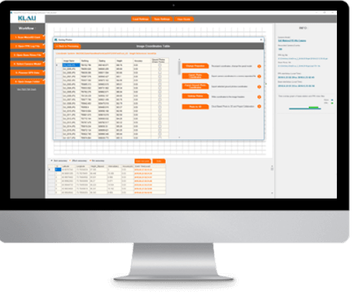
A streamlined workflow to create accurate camera positioning in any coordinate system.
KlauPPK software enables professional users to achieve the most accurate and reliable results. PPK does not require a real-time connection to a base station. Not only does this save you time in the field, but the data collected is complete, with no losses due to communications links or range. This means better data quality, and with rigorous post-processing, the solution is more accurate and reliable than a real-time RTK solution.
The KlauPPK software solution now also offers PPP post processing for a no-base-station solution. A subscription to satellite corrections data is required for real time PPP, or the data can be pushed to MakeItAccurate for a post processed solution.
Full Software Suite to create accurate PPK or PPP camera positions in any coordinate system.
PPP Near Real Time Corrections Service to access satellite clock and ephemeris data and precise ionosphere modelling for PPP (no base station) processing.
No Survey Equipment or GCPs Required. Using the KlauPPK software, you can use your drone as a survey grade receiver, to collect any number of check or control points. This optimizes your equipment overhead and reduces field time and operational costs. You no longer need to place and recover smart ground control points or measure targets with survey equipment. (unfortunately you can’t do this with DJI drones).
Integrated PPK Base Station Data. KlauPPK software has seamlessly integrated both free and commercial CORS data sources in most parts of the world. This enables users to process their PPK data without having to set up a base station or search for the right data.
Integrated Real Time PPP Global Satellite Corrections Data. KlauPPK software will automatically apply your corrected trajectoryto provide high accuracy post processed positions anywhere in the world without any base station data. This service is locked to KlauPPK hardware products.
3D Lever Arm Correction. This feature brings even more precision to the computed results by modelling the 3D offset between the GPS antenna and the camera centre, or lever arm, which changes as the drone tilts in different directions. This enables the software to determine the exact camera centre position for each photo.
Geoid and Coordinate System Support. KlauPPK software converts the default WGS84 geographic coordinates to any published coordinate system and applies the geoid separation. Users can also add a new coordinate system, perform datum transformations and site localization to calculate accurate camera positions in their local site frame of reference.
Smart Geotagging. Computed high-accuracy camera positions with their horizontal and vertical accuracy values can be written to the image EXIF data, or to a text file with other survey report information. The accuracy values are applied in photogrammetry processing software, again helping to achieve the best possible results.
Added efficiency, reliability and accuracy.
Software Comparison
Klau Geomatics has software options to suit your requirements, whether you are using KlauPPK hardware, DJI RTK hardware or other GNSS systems on any static or kinematic survey applications.
3rd Party Software
Inertial Explorer
NovAtel’s renowned software for high end GNSS IMU processing – IE
Inertial Explorer, matched with the NovAtel hardware in the Klau Geomatics products, produces the best possible position and attitude accuracy for your applications. Terrastar-C Pro integrated for PPP NRT solutions. The gold standard in GNSS/IMU coupled post processing software.
Contact Klau Geomatics to purchase your perpetual or annual desktop licence of Inertial Explorer.
Online training and support is also available.

Agisoft Metashape
Klau Geomatics and 4DMapper work closely with the Agisoft team to help bring to life the latest technology in photogrammetry.
Agisoft Metashape is a world-leading photogrammetry product. Well established as the choice for ‘hands on’ photogrammetry for drones and manned aerial mapping, Metashape gives users the control they need to get the best possible results from their aerial data.
Contact Klau Geomatics to purchase your desktop licence of Agisoft Metashape.
Online training and support is also available.

Global Mapper
From Blue Marble Geographics, Global Mapper is the go-to software for geospatial data analytics
Global Mapper® is a cutting-edge GIS software that provides both novice and experienced geospatial professionals with a comprehensive array of spatial data processing tools, with access to an unparalleled variety of data formats.
Contact Klau Geomatics to purchase your desktop licence of Global Mapper. The best money you’ll spend on GIS software.
Online training and support is also available.


Geospatial Data Management, Visualisation and Collaboration
4DMapper, developed by Klau Geomatics, is a deployable platform to manage visualise and collaborate with geospatial data.
The data deluge, with the uptake of drones, laser scanners, low orbit satellites and other sensors in the geospatial sector, has created a massive problem in data management and distribution. Klau Geomatics set out to create an accessible platform to exchange data between the data acquirers such as drone operators, geospatial experts adding value to this data, and end users requiring easy access to visualise the products and create useful outcomes from the data.
4DMapper Pty Ltd was launched in July 2015, enabling users to upload, view and share geospatial data. Tools were added to measure points lines areas and volumes, to extract (digitize) these markups, with multiple users enabled simultaneously, to support 3D Mesh models and many other formats, with tools inspect, tag and build a database of insights.
To meet the needs of enterprise cusotmers, 4DMapper can be deployed on dedicated cloud or local infrastructure, to connect to existing data storage, applications and workflows.
4DMapper Pty Ltd continues to develop innovative technology in streaming 3D geospatial data.