by Klau Geomatics | May 4, 2020 | Testimonials
After conducting numerous missions of trial areas, as well as comparisons to physical GPS/laser scanning surveys I have observed the following accuracies: Camera accuracy MAX 30mm (as reported in agisoft) PPK accuracy AVG 12mm (compared to RTK points) GCP accuracy AVG...
by Klau Geomatics | May 4, 2020 | Testimonials
The experts at Klau Geomatics have really revolutionized precision drone data collection with their PPK unit. The system allows us to outfit our existing equipment with accurate camera positioning. –Matt Mercurio; Spatial Analytix, USA
by Klau Geomatics | Mar 10, 2020 | Press release
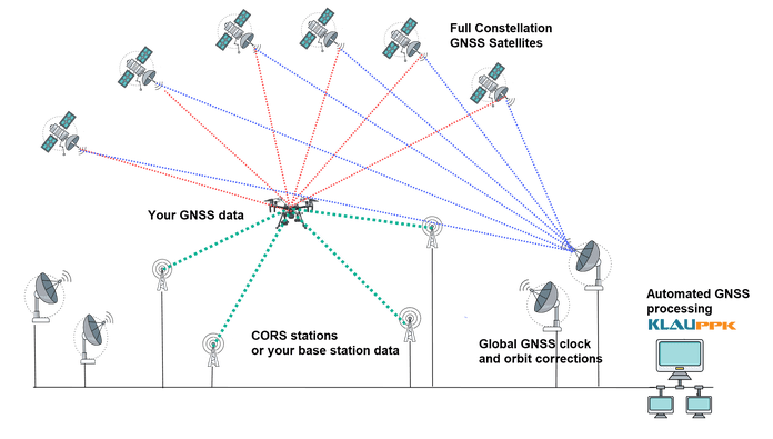
Post Processed Kinematic (PPK) has been the positioning tech of choice for the past few years. Drone operators have seen the advantages of PPK over RTK in the quest increased efficiency and accuracy with less dependence on Ground Control Points (GCPs). Now Precise...
by Klau Geomatics | Feb 10, 2020 | Testimonials
We conducted a ground-based site surveying by qualified surveyors with survey grade total stations to evaluate the accuracy of the KlauPPK system. Then with a Klau calibrated X4s camera on a DJI Inspire2 drone we captured aerial data at a 10mm ground sampling...
by Klau Geomatics | Jan 13, 2020 | Press release
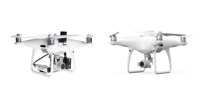
Over the past year or more the Phantom 4 RTK has become the popular entry-level mapping drone. But now with its older brother, the Phantom 4 Pro, back on the block, it’s worth taking a good look at how these drones go head to head on surveying and mapping. To bring...

Recent Comments